Way back when, all the new TV shows would be broadcast in the fall, and when summer rolled around, nothing new was ever on – it was all reruns. In the world of television, summer reruns aren’t a thing anymore. My compulsion to hike to lakes I’ve not been to before is as strong as ever, but sometimes convenience is a stronger factor.
June 10 – Forest Lakes – Picnic with Bullwinkle
For years, my traditional first hike of the year was Emerald Lake in Rocky Mountain National Park. Familiarity breeds contempt, and while I don’t feel contempt for Emerald Lake, the appeal has lessened somewhat. The last handful of years, I’ve been starting my hiking season with a trip to Forest Lakes in James Peak Wilderness. The lower Forest Lake, specifically.
I wasn’t going to write anything about this trip. It’s a rather run-of-the-mill forest hike with no grand vistas (or vistas of any kind, really), and the views from the shores of the lakes are not exactly spectacular. I keep doing this hike in late May or early June because, due to the snow, it’s a different hike every time. But, generally not noteworthy.
This year, we had a very dry winter with the mountain snowpack much reduced from normal. And I was doing this hike a week or two later than normal. Still, I was surprised that I didn’t encounter any snow at all on the trail. That made it easy to find a spot for my picnic. I found a nice slab of rock near the outlet. Because the area around the outlet is fairly marshy, I was on a bit of a peninsula.
Selfie with Bullwinkle
Gotta scratch that itch!
Proximity
I was there about 45 minutes and had had enough. I’d have been happy to sit there for an extended time, but it was a bit breezy, so when I finished my lunch, I packed up to leave. That’s when Bullwinkle showed up. He looked at me, and we acknowledged each other’s existence, me on my rock, him standing a few feet from the dry ground I wanted to make my exit over. So I waited.
He munched on the grass and flowers. He scratched himself. He ate some more. He scratched some more. Occasionally, he’d give me a look. Then he’d go back to eating. I watched him eat his salad for 45 minutes, by which time he was far enough from my path of egress that I was willing to go around him. Moose are unpredictable. And moose eat constantly. I don’t think I’ve seen a moose that wasn’t eating.
June 21 – Neva Lakes – Thieving Marmot
For Father’s Day, I was invited to go take a hike. No, not with my loving family. Just me. I’m okay with that.
I decided to venture to Neva Lakes. I was there a couple of years ago, late in the season, in October. It’s a fun hike, with a nice stretch of it off-trail through a valley of winding streams, ponds, and thinly scattered trees. The lakes lie a bit below 12,000′, beneath the Continental Divide in Indian Peaks Wilderness. Being that it’s still June, even though the snowpack is less than normal, I figured I’d encounter some snow.
I reckon I made it to within about a quarter mile of the lower lake before I stopped. I faced a steep climb over snow, into a stiff breeze. I knew the lake would be icebound and the wind would only be worse, not better. It wouldn’t be a very comfortable picnic spot, so I stopped where I was: a small, unnamed pond in a bowl that was somewhat protected from the wind with a nice view of the mountainside below Lake Dorothy.
At one point, I was eating my sandwich and set my beer on a rock. Then I spotted a marmot. I wasn’t sure he had seen me, despite my wearing my red jacket. He clambered down some rocks to a patch of snow. He crossed that, then started coming straight in my direction. I shifted my weight from foot to foot, which caused him to panic a bit and run for cover. He has certainly seen me now.
A few seconds later, he was over his shyness and back on a path straight toward me. Usually, marmots are quite shy. They’re not like the ground squirrels that have no manners and aren’t above digging through an unwatched pack. Generally, if I get within 20 feet of a marmot, it’ll go for cover.
This one, though, was on a mission. I just didn’t know what it was. Here’s where I made a small, incorrect decision: I had my phone out to take pictures of the little guy. I should have been recording a video.
His mission was to steal my beer. I had no idea marmots liked beer, or would even have any concept of how to make off with a can of beer should they come across one. I stood there, dumbly, as he snuck up on my beer. At first, I thought he was just curious and wanted to sniff it. Before I knew it, he clamped his teeth on the top rim of the can, picked it up, turned around and started away. He gave me a bit of side-eye, and I think he may have thought he was invisible. I hollered at him and took a couple of steps toward him before he dropped it, spilling about a third of what was left in the can.
Mount Jasper
Aint I cute?
Just before he grabbed it and ran!
He didn’t run off very far after that. Perhaps he was hoping I had a second beer and was more willing to share it. He sat on a rock, splooting, trying to look cute or something, unbothered by my harangue about low-down, beer-theiving, no-good rodents.
My front yard has looked subpar like hell for quite a while now. The row of flowers in front of the deck has lost its fight with entropy and now looks more like weeds. Sure, the occasional tulip or poppy makes an appearance for a few days, but it’s just sad.
The lawn has large bare spots through some combination of too much shade cast by the maple trees and not enough water.
For a while, I’ve been thinking about doing something about it. Now, with this year’s drought in full force, Genae suggested we remove the lawn and put in rock. Since that was pretty much exactly what I was thinking, I seized the moment.
I had my sprinkler guy cap off all the existing sprinkler heads and run a line for drip irrigation. We picked out some granite that’s gray and black with some red highlights. I did my calculations and ordered 7.5 tons, along with some edging material and weed barrier fabric. The tough part, for me, is picking out plants. I tried a few years ago, and nothing I planted made it to the next year. If at first you don’t succeed, try, try again.
The rock came off the truck looking a dull, uniform gray. I was thinking maybe they’d delivered the wrong stuff until I washed a handful of it off. It was just covered with mud. When I finished putting the rock down, I was sure I looked a bit odd watering it. “Hey, Dave! That rock won’t grow no matter how much you water it!”
The car show at McPherson College is run by the C.A.R.S. Club. That acronym stands for College Automotive Restoration Students. Any student enrolled in the college can join. Their big event every year is the car show in the spring. It’s the reason for our trip.
This year, 507 cars were entered, so it’s quite a large show. To compare, the Colorado Concours d’Elegance draws a bit over 300 cars. The Barrett-Jackson Auctions I attended years ago drew over 600 autos. The emphasis at McPherson is on domestic autos – there were no Lotus, for example. I’m going to go out on a limb and say that there was only a single representative of any given marque. Okay, okay, there were a lot of BMWs and a few Porsches. There were two cars there from the Soviet Union: a 1982 Zaporozhets and a 1988 Moskvitch. Both of these were student cars. I overheard the owner of the Zaporozhets saying he was still able to get parts, but only from Ukraine.
It was nice to be able to take a look at the classrooms/workshops that the students worked in. The college continues to be the recipient of large donations, and this year, they unveiled their plans for significant upgrades in this building, resulting in about twice the floor space. There are about 300 students enrolled in the program.
There were quite a few cars there that I’ve never seen before, including a trio of Cadillac concept cars. Concept cars are where the designers are showing off their wild ideas and aren’t particularly interested in actually putting them into production.
Quite a few antique cars were on display. I was looking at one of the student projects when I realized why we call the trunk of the car the trunk. Most of these early autos had no storage space at all, so there was a rack where you could carry your luggage. Specifically, a steamer trunk. Trunk! Get it? I finally did.
In the run-up to our trip, I was thinking this would be a one-and-done thing. It’s a long way to go over boring roads for a car show, and we’ve picked the low-hanging fruit when it comes to additional sights to see. But I’ll admit to pondering the possibility of going again in a couple of years just for the show. Can I do a “blitz” trip – drive the day before, enter my car in the show, and drive home immediately after the awards ceremony? Hmmm.
We ran into LoCo members Steve and Julie, and after the show, met current LoCo member Mark and former member Doug for beers at Three Rings Brewery.
And that was it for Saturday
1908 American Underslung
Cadillac Concept. With the bubble top on, how does one get in?
1967 Lamborghini 400 GT 2+2
1919 Locomobile
1952 Chrysler Ghia Special
Ralph Nader’s inspiration: unsafe at any speed!
Body shop
By roughly noon on Sunday, our Kansas sojourn was over – we had made it back to Colorado. Not that the roads or scenery became much different when we crossed the border; we still had a few hours of dull driving. But first, we arrived at our last attraction.
Amache
Let’s get this out of the way up front. I think most people, when they hear the term “concentration camp” immediately think of Auschwitz. There is a huge difference between a concentration camp, such as the Granada War Relocation Center (now designated the Amache National Historic Site), and Auschwitz. Amache was a concentration camp, and Auschwitz was a death camp. Here’s one popular dictionary’s definition:
Concentration camp (noun): A camp where persons are confined, usually without hearings and typically under harsh conditions, often as a result of their membership in a group the government has identified as suspect.
— The American Heritage® Dictionary, 5th Edition
Amache fits the definition perfectly. Executive Order 9066, signed by FDR on February 19, 1942, authorized the removal of more than 110,000 Japanese-Americans from the West Coast to camps like this one. There were no trials. These people lost their homes, businesses, and freedom. This part of eastern Colorado sees temperatures over 100°F in summer and below 0°F in winter. There are no trees, and the soil is not conducive to cultivation. They were moved here solely due to their race. The stated reason was to defend against sabotage and espionage, but none of them was ever even accused of these crimes.
The various exhibits here have conflicting data. One said 10,000 people were imprisoned here, another said 7,500, and a third said 7,300. I may have misread the high number. It may be that there were 7,300 imprisoned and more than 2,000 people to run the place. In any event, this barren landscape was transformed overnight into the tenth-largest community in Colorado. Much of the land used for the camp, and the fields surrounding it, subsequently farmed by the residents, was confiscated from local landowners by the government.
It struck me as a bit odd, using that phrasing: tenth-largest community. Why not say “city” or “town”? I wonder if it’s worded that way so that it includes somebody who might be left out of statistics for some administrative reason, like reservations. Also, “tenth-largest” surprised me. According to FRED, the population of Colorado in 1941 was 1,124,000, with about 324,000 in Denver. Colorado had a much more rural population back then, as is obvious to anyone who drives through the small towns. I’m surprised that Amache was the tenth-largest community in the state, but I don’t doubt it.
One of the exhibits (sadly, I neglected to take a photo) discussed education in the camp. Authorities had difficulties recruiting teachers. Who would want to move to the middle of nowhere? This exhibit tells us that the curriculum attempted to eliminate the teaching of Japanese culture and customs and inculcate American values like freedom. Let that sink in for a moment. We want to teach people who are held without trial on confiscated land about how much America values freedom.
The camp covered 10,000 acres, mostly for cultivation, with a square mile inside the wire. Something like 250 barracks were built. The foundations were poured on top of the ground. That is, no trenches were dug – they just put the forms on the ground and poured the concrete. The barracks were uninsulated and heated only by cast-iron stoves. The place is windy all the time.
Today, there are replica buildings: the recreation center, a barracks, a guard tower, and a water tower. The cemetery was outside the wire; it’s the only place that’s green – trees to shelter from the wind, and a green lawn.
Landmark Erected 60 Years Later
Under the Machine Gun
Vast Emptiness
Crumbling Foundations of Democracy
Cemetery Monument
I never learned about these camps in school. The Executive Order was mentioned in class, and we heard about camps in the California desert, but not that there was one nearby. I first heard about Amache from a friend whose parents were there. As a World War II buff, I knew about the 442nd Regimental Combat Team, comprised of men from the camps and the most highly decorated unit in U.S. military history.
After the camp was closed, there was no attempt to preserve anything, just like at any other similar sort of camp. I’d like to visit the site of a camp where we held German POWs, but the same is true with them. What’s to preserve? All that’s left of what was there in 1945 are the foundations, crumbling.
Will Alligator Alcatraz get preserved when (if?) it closes?
Should our school curriculum include the study of Executive Order 9066 and these camps? A common feeling among Americans today is that we should teach only the good things from our history. Many feel that teaching about, say, slavery or the Trail of Tears, will only make students “feel bad” about being an American. We should teach “American exceptionalism”, our support of democracy, and freedom. To me, this is a bit like having a doctor who won’t give you a diagnosis of diabetes because it’ll “make you feel bad”. The result is you just get sicker. To put it another way, what would most Americans think of education in Germany if the Holocaust wasn’t taught there?
Long-time readers will react to me saying “I go to a lot of car shows” with an emphatic “DUH!”
Before the blog, when I lived in Phoenix, I attended several Barrett-Jackson auctions, which, if you’re not buying, are just big car shows where every car is for sale. I went to a couple of Copper State Rally shows, where all the cars embarked on thousand-mile tours. The first place I saw an Elise was at an English car show there. Since I got the Elise, I’ve entered the Colorado Concours and the English Motoring Conclave several times. I’ve been to a couple of dozen Cars and Coffee events. I’ve taken tours of restoration shops where I’ve seen multi-million dollar Bugattis and Ferraris. I’ve seen exotics, muscle cars, race cars, hot rods, antiques, low-riders, motorcycles, tractors, and fire trucks. I’ve never had to drive more than about thirty miles to go to any of these.
So, when a Lotus Colorado member told us about a big car show at McPherson College in McPherson, Kansas, my first thought was, “That’s a long way to go for a car show!” I think it’d be a fun trip to go to the Pebble Beach Concours in Monterey, California. It’s one of the world’s great car shows. Although it’s more than twice as far as McPherson, it’s through some fine scenery and over twisty roads through the Rockies and Sierras. To get to McPherson, it’s eastern Colorado and western Kansas.
And how does the show in McPherson compare to any others I’ve been to? They have a renowned auto restoration curriculum there, and the students entered a car they worked on into the Pebble Beach show and won the top prize. The show is run by the students, and several of the cars on display are student projects.
Club members didn’t express much interest, and I had pretty much decided not to go when Chad called and said he’d drive us in his Maverick rather than the Lotus. I thought, “What the heck,” and said I’d go. We both had the condition that we’d have to include some interesting side-trips to sweeten the pot. In nearby Hutchinson, there’s a salt mine you can tour, and there’s the Cosmosphere, a space museum. As a bonus, on the drive back, we can stop at the site of a World War II Japanese Interment camp. (A tip of the hat to Jim for his helpful suggestions.)
So that was the plan: salt mine, space museum, car show, and concentration camp.
Thursday was the drive to Hutchinson. There’s not much point in describing the route or the views. After checking in at the hotel, we went to the Salt City Brewing Company for beer and dinner.
Strataca
About a century and a half ago, a man drilled for oil but found salt instead. Today, you descend in a hoist 650 feet down to the mine, where you find over 150 miles of tunnels, a small sample of which you are allowed to explore.
We did the basic tour and added the Lantern Tour, where we were taken deeper into the darkness. The guide compared it to the surface of the moon: no wind, no weather, nothing to disturb the footprints miners made 80 or 90 years ago. It wasn’t worth the effort to haul the miners’ trash back to the surface, so we occasionally came across piles of perfectly preserved trash – cardboard dynamite boxes still like new (but empty of dynamite), newspapers and magazines and those conical water fountain cups looking as if they were discarded yesterday.
Generally, the caverns are fifty feet wide, separated by fifty-foot-wide pillars, making a sort of giant waffle iron. The walls are salt, the ceiling is salt, the floor is salt. It looks like rock, stratified by bands of dark and light. We are told the salt is 95% pure, with some formations reaching 99%. We were also told not to lick the walls. The salt mined here is used on icy roads and as cattle feed. There is red salt in places, but they don’t mine it as the cattle won’t eat red salt.
So, what is there to see in a salt mine, other than salt? First, there’s the obvious display of the mining equipment used over the decades, along with helpful videos explaining how the salt was (and still is) mined. After several such exhibits, we turned a corner to find … a Civil Defense shelter! As a child of the 60s, I’m well familiar with the lore. But before now, I’d never seen what someone hiding from nuclear holocaust might eat. I imagined stacks of canned green beans (and was not disappointed to see them), but didn’t realize that crackers, biscuits, and carbohydrate supplements were distributed in giant cans, along with 17-gallon drums of water, complete with instructions to turn the drum into a commode.
Also, because of the constant temperature and lack of humidity, a salt mine is a great place to store things you want to preserve, such as paper documents, computer tapes, and old films and movie memorabilia.
Detail of salt mine wall
Fifty foot wide gallery
Mining equipment
Survival water
Civil Defense supplies
Buried “Friends”
Cosmosphere
Now and then, I come across something that seems out of place. The world’s foremost pre-war Bugatti restoration shop used to be in Berthoud, Colorado, a town so small it has no traffic signals. How did that happen?
The Cosmosphere is a space museum that rivals the Air and Space Museum at the Smithsonian. How did such an impressive museum come to be in Kansas? Florida or Houston would be obvious choices. Huntsville or Pasadena, maybe. But Hutchinson, Kansas? Go figure.
It concentrates on space, not aircraft, so it’s not as big, but the collection of space artifacts exceeds what I saw at the Smithsonian. Some of the exhibits here are on loan from the Smithsonian, and some are from private collections, but much of what’s on display at the Cosmosphere is from their own collection.
There are a few aircraft here, like the SR-71 Blackbird. How do you get your SR-71 inside a museum? That’s a trick question: you build the museum around the plane.
Their exhibits cover the entire history of manned spaceflight, from the origins in Nazi weapons (the V2 was the basis for the Redstone rocket) to a SpaceX Merlin engine. I was particularly impressed by the quantity of Soviet gear here. I want to make a joke that this is the entire collection of Soviet space capsules that didn’t blow up on launch or on landing
I was surprised to learn that the Cosmosphere restores these artifacts. It’s not like restoring an eighty-year-old car that can be driven on the road – the spacecraft here in Kansas are only restored to look functional. Nobody is going to fire up that rocket engine or launch this capsule. Still, how do you go about getting a job as a restorer of antique Soviet spacecraft?
These guys restored a V2 they found in a barn. It’s fairly common to hear of rare old cars found in barns, but a V2? Incredible. And it’s not just “barn finds”. They have the Liberty 7 capsule. It was the second manned craft in the Mercury program, a sub-orbital flight carrying Gus Grissom. The capsule sank to the bottom of the ocean after they got Grissom out. It was recovered from the ocean floor in 1999 and was restored by the museum. Amazing.
Lunar Lander and Rover
Apollo/Soyuz
Liberty 7 capsule
V1 (green, left), V2 (black/white, right)
Gemini/Titan rocket
Apollo hatch opening/closing instructions
I assume the name “Cosmosphere” is a play on Cosmonaut. I recently learned the origin of the word “Cosmonaut”. I thought it was simply from “cosmos,” an alternative name for the universe. Instead, it comes from “cosmism” – a Russian philosophical movement integrating science, religion, and metaphysics into a unified worldview and characterized by the belief in humanity’s cosmic destiny, the potential for immortality, and the use of technological advancements to achieve control over nature and explore space. Believers in cosmism imagined immortality for everyone and the resurrection of all past people. (Now I can’t help but wonder if Philip José Farmer looked into it before writing To Your Scattered Bodies Go.)
After exploring space technology, we continued our exploration of local brew pubs. Tonight it was Sandhills Brewing. As a fan of fruit sours and goses, I liked their selection of beers. No kitchen here, but the food truck outside had a selection of tasty foods.
When we planned our activities for this trip, we thought it was a good idea to have a rest day after we arrived in Belize and another rest day before we returned home. I’m not going to say it wasn’t a good plan, but in retrospect, I’d rather have visited another Mayan ruin: Cerros than hung around Consejo. Cerros isn’t far from Corozal, although I’m guessing the roads are not very good.
In any event, Friday was a day of relaxation. This was not a bad thing. You see, I managed to take a trip to the Caribbean and catch a cold. Our second night here, we had a fan running in the bedroom to serve as white noise. I awoke in the early morning with the fan blowing on me. I had a bit of a scratchy throat. I was thinking this was because the fan had dried me out. I was thinking incorrectly.
Half a lifetime ago, every time I flew on a plane, I caught a cold. I’d take vacations in Phoenix and spend the whole time sitting in the sun in my parents’ backyard, sniffling and sneezing. Sometimes, I’d get back home after the vacation and take a couple of sick days. I flew to Louisville, KY, for work once and had a miserable cold. The hotel was full of military personnel for some reason. It was when Operation Desert Shield turned into Operation Desert Storm. I slept through most of the war, although I could occasionally hear the cheering of the military guests. Catching a cold every time I flew was beyond annoying.
Luckily, when I started travelling every week for work, I was no longer catching colds on every flight. I don’t know why the godz decided to remind me of that history and knock me down with a cold on this trip, but so it goes. I was mostly functional during the day, although some days I could hardly talk. When we’d get back to Greg’s, though, I’d relax and try to take a nap.
So a relaxing Friday wasn’t a bad thing.
One of Greg’s neighbors
Strange rash
A cold isn’t the only thing I picked up in Belize. By Friday, I had a rash of some sort on both forearms. Nowhere else, and not under my watch. If it was from the sun, why only on my arms? If it was from the sunscreen, again, why only on my arms? I never did figure it out; the rash was gone a couple of days after returning home, before I recovered from the cold.
February 21
When we bought our tickets, the original return flight was to change planes in Houston Hobby. It was a nice surprise that, a few weeks before we left, Southwest notified us that they’d changed us to a direct flight. It makes for an easier day for us, but I’d never been to Hobby before, and that would have been the 57th airport I’ve travelled to/from/through.
Greg said somebody told him that there were 85 speed bumps between his place and the airport. That seemed like a reasonable number, but it didn’t stop us from counting them. Our tally could be off by one in either direction, but we counted 74.
Returning the rental car was quick and easy compared to picking it up. We were quite early, probably could have waited another hour before leaving Greg’s, but it’s better to be early and have time to kill than to be late and miss our flight.
After we got checked in and dropped off our baggage, we went to the restaurant for lunch. We all had grilled ham and cheese – not exactly traditional Belizean fare. This was one of the few places I could find a sugar-free soft drink. Nobody had “diet” anything; a couple of places had Coke Zero, and a couple of places had unsweetened iced tea. I don’t normally consume alcohol when I’m feeling poorly, but when I couldn’t get a sugar-free soft drink, I resorted to beer. Done with lunch, we headed to our gate.
I hadn’t given much thought to how the gates work in an airport with no jetways. We were at gate 6, way at the end. (One tactic Southwest uses to keep costs low is to rent the gates and baggage carousels that are the farthest away. The rent on those is lower.) We weren’t the only people who were early. There are maybe 80 seats at gate 6, with similar numbers at the other gates. A 737 has something like 180 seats, so if the only people waiting here were for our flight, there’d be a bunch of people standing around.
From the flight status monitors, I saw that there was a flight leaving from gate 6 before ours, and there looked to be two flights’ worth of people at gate 5, too. Out the door at gate 6, we could see a plane. It was a different airline than any of the flights leaving from gates 5 and 6. It was then that I realized that the planes just come in and park at any gate, and departing passengers are led out the doors at their gate and ushered to wherever they need to go. So the folks getting on the plane at gate 6 could be coming from any gate, and when we walked out, we’d be marched to a plane anywhere in the line.
Our flight was on time and uneventful.
It was a good trip. We hadn’t seen Greg for ages, and it might be some time before we see him again. We thoroughly enjoyed all of our excursions, and the weather was nice.
That said, I found Belize a nice place to visit, but I wouldn’t want to live there. I’m a desert boy. Denver isn’t exactly desert, but it’s dry here, and I’m not a big fan of high humidity. The temperature in Belize was within a degree or two of 80 for our entire stay, with high humidity. I looked forward to a shower each day, but within minutes of getting out of the shower, I found myself thinking, “I’d really like a shower!” I lived in South Florida for a bit less than a year and never did get accustomed to the humidity.
For me, today was the highlight of the trip, the thing I was most looking forward to: a visit to a significant Maya site. Genae had done the trip planning for everything else, but today was Greg’s idea. I think he nailed it.
There is a road to Lamanai, but we’re told you’d have to be a masochist to use it. Instead, we signed on to a tour with Lamanai Eco Tours. They can be a bit difficult to find, so we were directed to look for signs for Bat’s Landing, a bar and grille, a few miles from Orange Walk. From there, we’d take a 22-mile boat ride up the New River to the site.
In our travels around Belize up to now, we’ve passed several police checkpoints but were never stopped. Today, just before we reached Orange Walk, we finally passed through an active checkpoint. We were flagged down, and I was asked where I’m from. “Colorado, USA,” I answered. He asked for my driver’s license. He inspected it closely, but I doubt he’d know a valid Colorado driver’s license from a fake one. He read out my name, and I answered that, yes, that was my name. “Go ahead,” he said.
On the trip to the site, our boat captain stopped several times to point out some of the local wildlife. I found this quite impressive. First, the river is a maze of islands and tributaries. Once we were going, the captain would open the throttle all the way, lifting the nose of the boat, throwing lots of spray, and leaving a big wake. Then he’d spot something, throttle down, and nose the boat toward one shore or the other. He’d get his laser pointer out and show us where a turtle or crocodile or iguana or tree full of bats was. I reckon we were going about 22 knots at full throttle. The crocodile he spotted had just its nostrils and eyes above the water. The turtle was just as hard to spot. I can believe that the bats rested regularly in the same tree, but I doubt he was finding the other animals in the same places. Very impressive wildlife spotting skills, for sure.
It took us a bit more than an hour to get from Bat’s Landing to Lamanai.
On shore, we were handed off to a new guide. I didn’t get his name, but he told me he’s been a guide at Lamanai for 23 years. He was most knowledgeable about the ruins. Although I didn’t spot any archaeologists working, it is an active site, with one structure being reclaimed from the jungle only in the last seven months.
We were told that “Lamanai” means “submerged crocodile.” Our guide told us that that’s a bit of a mis-translation. He said it’s actually “Lama’anayin” and means something like “squashed bug”. I don’t recall exactly what he said, so I probably have it wrong. I haven’t been able to verify it one way or another.
As is common with Mayan ruins, the structures were built up over centuries: Postclassic structures were built on top of Classic ones, which were built on Preclassic. The Preclassic structures in Lamanai may also have been built atop Archaic ones, but that wasn’t clear to me. The faces at Mask Temple all have Olmec features. The Olmecs predated the Maya, and “disappeared” about 400 BCE. I put “disappeared” in quotes because the Maya people are still here, post-Conquest, just as I’d guess the Olmec were still around when the Maya gained power.
We toured the major structures – the Jaguar Temple, the Ball Court, the High Temple (“El Castillo”, but not to be confused with El Castillo at Chichen Itza), and the Mask Temple. I was most surprised by the Ball Court. The one at Chichen Itza is the largest ball court in the Mayan empire, much bigger than a football field. The one here is… not playable? It’s only about ten feet wide and thirty feet long and has a round stone dais in the middle of it.
I was glad that we tourists are still allowed to climb on the pyramids. We were lucky enough to do this at Chichen Itza 32 years ago, but they no longer allow it. Here, the High Temple even has a modern set of stairs built on it.
Our guide at one point called out a major difference between Chichen Itza: the water situation. Chichen Itza is on the Yucatan Peninsula, which has no surface water. That is, there are no lakes or rivers there. Their water sources were “cenotes”, which are large sinkholes. In dry times, the cenotes were under threat of failing to meet the needs of the city. Lamanai is built on the shores of a lake, and water was never a problem. At Chichen Itza, they had human sacrifices to appease the gods to supply water. There were no human sacrifices at Lamanai.
Here is a little history of Lamanai, from The Maya, by Michael D. Coe:
Far up the New River, a considerable distance to the southwest of Cerros, is the important site of Lamanai (known as ‘Indian Church’ on older maps of Belize), which has been excavated by David M. Pendergast of the Royal Ontario Museum during a series of field seasons beginning in 1974. Lamanai lies on a long lake formed by the river, and its 718 mapped structures are stretched out in strip form along its shore. There is even an ancient harbor in the northern part of the site, testifying to its entrepreneurial importance in the regulation of ancient Maya trade. While it was occupied from earliest times right into the post-Conquest period, much of its importance lies in the large, imposing, Late Preclassic temple-pyramids which usually underlie Early Classic constructions, including one with a plaster-work mask closely resembling those from Cerros.
Between AD 672 and 751 (considered by many to mark the civilization’s florescence), the number of communities carving new monuments continued to increase, but new construction took place only in already established cities. Maya civilization had ceased to expand geographically. From 751 to about 790, long-standing alliances began to break down, interstate trade declined, and conflicts between neighboring city-states increased (the battle of 792 commemorated by the Bonampak murals illustrates this situation). From 790 to 830, the death rate of cities outstripped the birth rate, while after 830 construction stopped throughout the Central Area, with the exception of peripherally located sites like Lamanai. The katun ending date 10.3.0.0.0 (AD 889) was celebrated by inscriptions at only three sites. And the very last Long Count date to be recorded anywhere was the katun ending 10.4.0.0.0 (AD 909), incised on a jade from a site in southern Quintana Roo.
I can’t help but recall a conversation I had with a couple of Dutch motorcyclists in the parking lot of my hotel in Nürburg last summer. I don’t recall how it came up, but they said something to the effect that “there’s no history in America”. It’s a common misconception, I think. There is quite a bit of history here between the Aztecs, Maya, and Inca, all of whom left major monuments, many of which predate Christ. But it’s not European history, and due to several factors, not as easily understood.
The Maya never developed paper, so all their history is documented in the stone of their temples or the jade of their jewelry. The temples were consumed by the jungle, and the Europeans looted the jade, which is now in museums or private collections worldwide. Even if the Maya had come up with paper, how long would any document have lasted in this climate?
This lack of a “written word” goes hand-in-hand with some other “failures” of Mayan technology. They never came up with the wheel. How primitive! But in this tropical, swampy environment, the wheel is worse than useless. It’s much easier to move building materials on poles carried by men. Any wheeled vehicle would bog down. They certainly had the concept of the wheel, though. In other cultures, the wheel is typically associated (right or wrong) with the arch and the dome. The Maya had arches, but they weren’t curved arches. You can mock up a Mayan arch using Lego blocks. The Maya did have domes, though. There’s the Observatory at Chichen Itza, for example.
The wheel also shows up in the Mayan calendar. Compared to the Maya, the Romans were downright backward when it came to understanding the calendar. The Romans kept having to adjust their calendar every several years because the months kept drifting – months are based on the moon, years on the sun.
The Romans also never came up with the concept of zero. Without a zero, large numbers are difficult to represent, and you can’t perform advanced calculations.
I’m not going to say that the Maya, Inca, and Aztecs didn’t fight wars (the excerpts above call some of them out), but I think there’s a definite difference between American history, pre-Conquest, and the Old World. When Europeans came to America, they brought disease, enslavement, genocide, and theft on a continental scale. It would be nice if Europeans (and those of us of European descent) were less proud of that history and more curious about the indigenous people of the Americas.
Jaguar Temple
Ball Court
High Temple (“El Castillo”)
Mask Temple
In front of the giant Olmec mask
The temples are connected with wide limestone gravel paths. Our guide pointed out that the path we were walking on was a narrower version of the original Mayan road. The new path was edged in stone. A few feet on either side of the new path was another set of boundary stones. The old set delineated the ancient Mayan road. I won’t say that these Mayan roads are as robust as ancient Roman roads, but the jungle is a much harsher environment than central Italy or rural England.
Early on the tour, the path took us beneath a large tree. The guide pointed to the upper branches where a group of howler monkeys was sleeping. A few steps later, we came upon a red stain on the path. Some predator had gotten one of the monkeys last night or the night before, and this was a blood stain.
After walking through the site and climbing on the pyramids, we gathered for a lunch of chicken and rice and beans, then went through the gift shops, where I found a shirt that could pass for an Aloha shirt.
A short while later, our boat came back to pick us up and return us to Bat’s Landing. The return trip was a bit quicker – not stopping to point out any wildlife, the captain kept the throttle wide open the whole time. On both the ride there and back, we were going fast enough that I had to take my cap off. If I didn’t take it off, it would have blown off. Without my cap, I managed to get a minor sunburn on my head. So it goes.
We were back to the car by 2:00 pm and had an uneventful, police-free drive back to Corozal.
I love visiting these old ruins and thought the day was a great success.
Breakfast at the hotel was much like you’d expect breakfast to be at any Ramada Inn stateside, but with a slightly different selection of fruit. The sausage was different – instead of patties or links, it looked like sliced-up hot dogs. I sampled it; it wasn’t hot dogs, but I can’t say for sure exactly what it was.
Genae found out that the Museum of Belize was nearby. We didn’t know if it was open yet, so we asked the hotel’s concierge. She said it was open and that we could get there on foot or by taxi. Instead, we drove. Yes, we could have walked it, but the roads are narrow and not particularly well set up for pedestrians.
The building the museum is in was built more than a century and a half ago by the British colonial government as a prison. The prison was shut down not long after independence, and in about 2002 was made into a museum chronicling about 3,000 years of history. It hosts a rich assembly of Mayan ceremonial objects, carvings, paintings, and other cultural artifacts. The story of slavery is told – loggers who braved malarial swamps and often tried to find freedom in Guatemala – and emancipation 15 years before our Civil War.
There are exhibits of the region’s animals. Each stuffed animal is accompanied by a sign telling visitors how the animal came to be here: killed by a vehicle, or died of old age. Animals aren’t represented only through taxidermy; there are some beautiful paintings and photographs. One exhibit tells about the destruction caused by Hurricane Hattie, which struck Belize in 1961. It was this hurricane that caused the capital to be moved inland to Belmopan.
Ex-prison
Mayan numbering – they had a zero!
Not Toucan Sam (Froot-Loops)
Our museum craving satisfied, we hit the road and headed to the zoo.
I’ll admit that I’m not the biggest fan of zoos. They always feel a bit wrong to me. Yes, it’s nice to be able to see these creatures, but they’re in jail! The Belize Zoo is a not-for-profit organization founded by Sharon Matola in 1983, who was caring for a handful of wild animals that had been part of a natural history documentary. When filming was completed, she was left with these animals and decided to start a zoo. The animals here are rescued, confiscated from the illegal wildlife trade, or transferred from other rehab facilities. Most of the exhibits have signs telling visitors how they came to be here.
When we were looking at the spider monkeys, a tour guide came up onto the platform leading a small group. Once the monkeys spotted her, they came running up to the fence. She tossed them bits of food, at first on their side of the fence, then on our side of the fence, which they could grab with their prehensile tails.
The howler monkeys were all asleep at the top of their tree. A sign said. “Please don’t howl at us, it causes us stress.” I don’t know if they’re nocturnal, but it was fairly hot out, and even many of the diurnal animals were sleeping in the shade.
Tapir
Spider Monkey
Harpy Eagle
American Crocodile
Iguana – a visitor, not a resident
Today’s beer
We had lunch at the restaurant at the zoo, bought some T-shirts, and then headed back to Corozal.
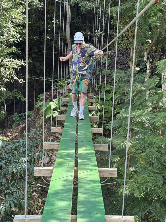
We left Consejo Shores early on our way to the Excalibur Adventure Park to enjoy the Via Ferrata and zip lines. We had 11:00 am reservations and didn’t want to get there late. It’s a bit southwest of Belize City, so we left some extra time.
As we got closer to our destination, the landscape transformed a bit, with small, steep mountains jutting above the otherwise pancake-flat terrain. This was a good sign: I was having trouble imagining zip lines without mountains.
I said earlier that the road signs look just like the ones at home. That isn’t entirely true – the signs warning drivers about the speed bumps were like none I’ve seen anywhere before. Today, we started seeing some new signs. They’re the usual amber diamond signs you’d see to warn you of deer crossing, but they weren’t for deer. Instead, we were warned to watch out for tapir and jaguar crossing the road.
It was only 10 o’clock when we pulled into the parking lot at Excalibur. It looked like we had an hour to kill, but they said we could start our adventure whenever we were ready. We pretty much had the whole place to ourselves.
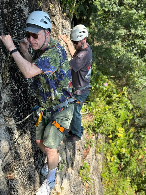
A via ferrata (“iron path”) is a protected climbing route over mountainous terrain. By “protected,” I mean strapped onto a heavy cable with a carabiner and a device called a “cookie”. The cookie is a squared C-shaped one, with the opening of the C smaller than the cable’s diameter. There’s no way to get the cookie off the cable except at the ends. The carabiner, on the other hand, can be removed from the cable at any time. The cable is attached to the rocks or bridges with a sort of plate. Orient the cookie such that the opening of the C can traverse the plate. At these connecting plates, we have to disconnect the carabiner and reconnect it on the other side. This system makes it impossible to come off the cable, which is reassuring for those of us who have problems with heights.
The original via ferrata was built by units of the Italian army during the First World War and was used to get men and supplies over difficult terrain. They’re now sprouting up all over the place.
This is my first time on one, and I didn’t really know what to expect. On this one, there are five bridges. Some thought went into the design. One bridge tends to bounce up and down when you cross it. Another bridge sways left and right, and another moves backward and forward. Yet another is simply a series of cables criss-crossed, and you need to step where the cables cross. Without the safety gear, I think I could have crossed these bridges, but it would have taken me much longer!
No photography is allowed on either the via ferrata or the zip line. Our guide, Sergio, was kind enough to take some photos. Along the way, he also pointed out some of the interesting plants in the area. One was the gumbo limbo, commonly called the “tourist tree”. The bark has a reddish tinge to it, and it peels off, much like the skin of sunburned tourists. It’s always near a black poisonwood tree. The bark of the gumbo limbo can be used to counteract the effects of the black poisonwood tree. Greg warned us of the poisonwood tree as he had a bad time with it in the jungles around his house. The effect is worse than poison ivy.
When we were putting on our harnesses, before starting off on the via ferrata, Sergio pointed out a coatimundi. The little guy moved too fast for me to get a picture. Oh, well. I’m sure we’ll get another chance to see one tomorrow at the zoo.
The start of the zip line is at the end of the via ferrata. Genae didn’t do the via ferrata with Michael and me, so she joined us here. The first platform is 275′ above sea level (and thus nearly that distance above the ground below). In all, there are five different zip lines that circle through the property, passing over the via ferrata and garden paths below, before ending not far from the start of the via ferrata. It was quite fun.
We ate at the restaurant there, delicious burgers and sandwiches (with buns branded with Excalibur’s logo), fries, and beer.
We didn’t originally sign up for any other activities, but Sergio told us a little about the caves they have there. One is a wet cave that you ride through on innertubes. The other is a short dry cave. We didn’t have our swimsuits with us, so we decided to take the tour through the dry cave.
Sergio told us all about the various formations in the cave – stalagmites, stalactites – and how water comes into the cave during the rainy season. I pointed out the bats that live there, and we even spotted a scorpion spider stalking a cricket. In the middle of the cave, Sergio asked us if we wanted to see total darkness. We turned off our headlamps for a short while. In our modern world, we rarely encounter total darkness. We literally couldn’t see our hands in front of our faces.
There are two short sections of the cave where you have to crawl on hands and knees, and one where you have to slither on your belly. I couldn’t help but wonder how they could politely tell your basic “Walmart shopper” they were too fat to make it through these sections.
Sergio was the first Belizean I’d had any sort of conversation with, more than a simple transaction at the store, anyway. I was expecting his English to be accented much like any other native Spanish speaker I’ve spoken to. But his accent had a bit of a Jamaican lilt to it. I noticed this accent when speaking to other Belizeans. I think I’ll change how I think of this accent – for me, now, it’s not so much a Jamaican accent as a Caribbean one.
Tapir crossing
Jaguar crossing
I can’t draw the sword from the stone…
Via Ferrara bridge
Hanging on the Via Ferrata
The view at the top, ready to zip!
Today’s beer
Bats in the cave
Done with our great time at Excalibur, we hit the road and headed to Belize City. Tomorrow we’re heading to the zoo, and rather than drive all the way back to Consejo, then all the way back here (the zoo isn’t far from Excalibur), we traded a night in a motel for all the driving.
The Ramada Inn, where we stayed, was right on the water. I was guessing half the rooms would have an ocean view, and half would have a “city” view, but all the rooms had ocean views. We didn’t want to tour the city after dark, so we had dinner in the hotel restaurant.
Today we toured the town of Corozal. In the weeks before the trip, when I told people I was going to Belize, everybody asked where we’d be staying. Nobody I talked to had ever heard of Corozal, and gave me blank stares when I told them it was close to Mexico. Undoubtedly, this reaction is natural. Corozal is not at all a tourist mecca.
We’re in Consejo Shores, not Corozal town itself. Consejo is an enclave of Canadian and US expats. It’s about 11 km of bad road northeast of Corozal and only a bit over a mile as the vulture flies from Chetumal, Mexico. Chetumal and Corozal are on the shores of the Caribbean (or Corozal Bay). A peninsula and islands to the east protect the shore from the worst effects of hurricanes and tropical storms, and the water here is too shallow for anything like a cruise ship. The closest tourist attraction is Ambergris Caye. All of Belize’s tourist attractions lie to the south of Belize City, which is a 2.5-hour drive south of Corozal.
Between Belize City and Corozal, the land is pancake flat, planted with sugar cane, palm trees for palm oil, and fruit orchards.
I was surprised to learn of the large presence of Taiwanese. Most of the stores and markets in the area are owned and operated by Taiwanese. Chinese names abound – Deng Shen, for example.
The official language of Belize is English. (The place was called British Honduras until 1981.) Spanish is common, and there’s quite a lot of pidgin English/Spanish – billboards with messages such as “Di Sun Serious!” abound.
There are hundreds of Mayan ruins in the region. I struggle to convey this properly. There are hundreds of sites, with each site ranging from a single structure still overgrown by the jungle to sites spread across hundreds of acres containing dozens of structures that are active archaeological projects.
Greg knew where one of these sites is in the middle of Corozal town. It took us a couple of attempts to find it, missing it by a block this way at first, then by a block that way. When we finally stopped to ask for directions, we were just a couple of hundred feet away, on the other side of a building.
The Santa Rita Archaeological Site is not much larger than a football field. It was first settled some time around 1200 BCE by about 150 people, eventually growing to about 6,800 people and controlling trade along the Rio Hondo river (which today separates Belize from Mexico). People here traded as far south as South America.
My inner 8-year-old couldn’t resist the urge to climb to the top of the pyramid.
We finished the day at a local pizza place. Rather than have another Belikin, I opted for a Landshark, brewed by Margaritaville Caribbean Brewing Company, based in Jacksonville, Florida. It was launched in 2006 by singer-songwriter Jimmy Buffett to compete against Grupo Modelo’s Corona. So, yeah, I went to a foreign country to drink a beer from Florida.
We left the house at 7:00 am for our 9:45 flight to Belize City. The fun began when we tried to check our bags. We’re all traveling on the same confirmation number. To begin the process, you need to let the kiosk know who you are. I’m using the Southwest app. You can scan the QR code, supposedly, but that didn’t work. After four or five tries, I gave up and just inserted the credit card I used to buy the tickets. Strike one against the app.
It has been a while since I flew out of concourse C. I was sort of looking forward to a bagel at Einstein Bagels, but they’re no longer there. Plan B was a breakfast burrito. Next, we headed to the gate. It was here that I discovered that the Southwest app wouldn’t bring up Michael’s boarding pass. When I went to get his boarding pass printed, I could no longer display either my or Genae’s boarding pass. Paper passes for all, then. I’m less than impressed with the Southwest app.
The flight was uneventful (as all good flights are). We didn’t notice until after beverage service was over that, it being Valentine’s Day, they were giving passengers free beer. An opportunity missed.
At the Belize City airport, they don’t have jetways – it’s old school. They drive the Arrested Development stair cars to the plane and we walk down to the tarmac. They did this at both the front and back of the plane, so deboarding was fairly quick. That was the last quick thing for the day.
A United Airlines flight from Denver landed just ahead of us. By the time we got in line for passport control, we were at the end of a line about a hundred yards long and about four people wide. After passport control, we go to customs. The guard let a bunch of people go without being queried about customs declarations, but no shortcut for us. We were asked where we were staying (“a private residence”) and who we were staying with. I gave them Greg’s name, but not an address or even the city he lives in. Just his name was good enough.
We were allowed to pass without being searched.
On to the car rental agency. I was third in line. It took about 45 minutes to complete the transaction. Basically, they were out of cars. One guy was told that his SUV had just been returned, but was having overheating problems. The next guy’s car needed to be washed – “It’ll only take 10 minutes. 10 Belizean minutes!” Our car wasn’t available either. Could we take a smaller car? Needing a car, I assented. “We’ll lower the price since it’s a smaller car.” The price given to me was $25 more than my original quote. That took another few minutes to fix.
We piled into our VW Nivus and headed out. To get out of the rental car parking lot, we had to pay $2 American (or $4 Belizean). I’ve never had to pay to get out of a rental car parking lot before.
Much of our 2.5-hour drive to Corozal would be in the dark on one of Belize’s best roads. (There’s a town called Corozal, in the district called Corozal. We’re headed to Corozal town.) This road is a two-lane highway, signed and striped just like roads here in the USA. The speed limit outside of the towns is 55 mph. But there are speed bumps on this highway. I’ve never seen speed bumps on a highway before. Most of them have warning signs. Most. I hit one of them moving at triple-digit speed. (The VW’s dashboard is set to metric.) Yes, we were going over 100 kph when I spotted the bump. I braked hard, but hit the speed bump harder. We did not catch air, but I was concerned I might have damaged the car. Good thing I got the insurance.
By now, it was getting dark. I got a dashboard warning telling me to turn on the headlights. Seems to me the car should be able to turn the headlights on automatically. It’s not new technology – I had it in a car manufactured last century. I couldn’t find the light switch while going 100 kph and keeping a watch out for speed bumps. Michael even did a quick (and fruitless) web search. I had to pull off the road to figure it out.
Back on the road, we began seeing trucks loaded with sugar cane heading the other way. The trucks were piled high with cane – far too tall to go under any US overpass or traffic signals. They all looked fairly precarious. Canes littered the road at each speed bump. The speed bumps, by the way, are called “sleeping policemen” by the locals.
The air was sometimes thick with smoke. When the cane is harvested, the fields are set afire. At one point, the horizon in front of us was orange with flame. A few minutes later, we saw the field that was burning – it came right up to the road.
Entering Corozal, we still had a bit of a journey ahead of us to get to Consejo Shores. It’s only about 7 miles, but it’s 7 miles of bad dirt road. It’s fairly heavily travelled, but punctuated by potholes small, medium, and large. I managed to miss most of the biggest holes while maintaining a more-or-less 35 kph pace: faster than perhaps I should have been driving, but too slow not to get passed.
We arrived at Greg’s a bit before 8 pm, which was earlier than Greg expected. I had a Belikin beer. This is perhaps the most popular beer in Belize, advertised at just about every cantina and restaurant between Belize City and Corozal. Compared to Colorado craft beers, it’s not great, but it was welcome after this drive. (The name “Belikin” is an amalgamation of several Mayan words meaning either “road to the east” or “road to the burning sun”.)
February 15
A lazy day today. For breakfast, Greg offered up some fresh fruit – guava, melon, pineapple, avocado – and banana bread.
In the early afternoon, it was off to the “beach” for volleyball. I didn’t play, but got into the water to float or sit on the bottom. There’s no beach here, and they play ball in the shallow water. The net is fifty feet or so from the shore, but today (even though some regulars said it was “deep” today), the water was about waist-deep. I ventured a bit farther from the shore, but never found deep water.
For dinner, Greg cooked up some sea bass and Spanish rice. We played games and chatted until after Greg’s bedtime.